Coastal Membrane: Engineered Flows Across the Nile Delta Estuary
AUTHORS
Tamer Elshayal
Vineet Diwadkar
LOCATION
Nile River Delta, Egypt
SUPPORT
Penny White Prize & Paul M. Heffernan Fellowship, Harvard University Graduate School of Design
The project is envisioned as a prototypical experiment about the instrumentality of idealized regional sections as gauge of flows through infrastructural networks. At first, reconnaissance mapping and site visits investigate the estuarine interface of the Nile Delta as a ‘cyborg’ landscape conjointly produced by hydrological processes and infrastructural modulations. Upstream water regulation structures and coastal protection works are the lens through which this reciprocal association between environmental processes and engineering control would be examined. Finally, a series of multi-scalar idealized sections of the coastal region are composed to juxtapose tidal ecologies, material flows, and infrastructural networks and structures.
Lying at the farthermost downstream point of the Nile River, the alluvial Delta is the final destination for the river’s water and sediments transported over 6,650 km before discharge into the Mediterranean. As such, the Nile Delta Estuary is a terminal site indicative of hydrological and political conditions prevalent in the whole Nile Basin shared by 10 countries. Upstream land use decisions and practices – the contentious Ethiopian Millennium Dam, land reclamation projects, or the water-intensive agri-/aqua- culture – determine the hydro-ecological conditions of the littoral zone, and hence the livelihoods of local communities. Production activities within the Nile Delta region include 40% of Egypt’s industrial activity, 50% of its protein production (through fisheries) and the majority of its agricultural production.

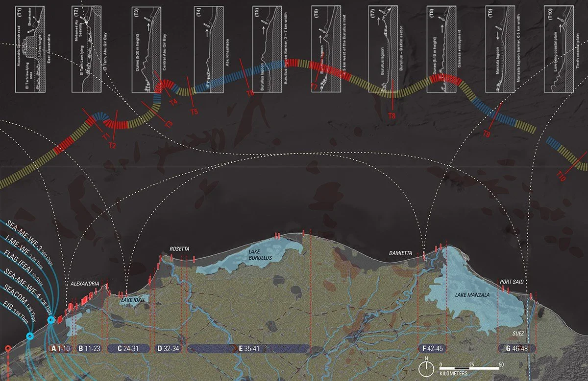
Simultaneously, this coastal region is a 300 km long stage for diverse types of infrastructural structures – coastal protection works, trading and fishing harbors, oil extraction platforms and shipping piers, canals and sluice gates – and hence is the product of intensive engineering control. The coastline is the start, intermediate and endpoint for a multitude of regional and global networks of circulation, for instance a landing site for submarine Internet cables, endpoint for regional oil pipelines, LNG export piers and harbors, trading and fishing ports and anchorage, as well as global shipping lines through the Suez Canal. Moreover, the littoral zone is continuously crossed by a diversity of exchange flows, for instance, salt and sediments through water currents, nutrients and toxicants through discharge canals, energy through oil and natural gas pipelines and export networks, raw materials and processed goods through coastal ports and shipping lanes, submarine data cables, as well as human and avian migration.
Accordingly, the littoral zone of the Nile Delta is both a synthetic assemblage of ecological and infrastructural systems as well as a membrane through which flows of materials, energy, people and information are intersecting and traversing. Consequently, the Nile Delta Estuary is a critical site for the investigation of how an array of global and local techno-natural circulatory networks are producing and modulating a manufactured coastline.
Project Description:
This project is based on the premise that estuarine zones, particularly when heavily urbanized, can be geographically conceptualized as exchange membranes for both biophysical and socio-cultural processes. The Nile River Delta is a hybrid landscape produced by hydrological processes of sedimentation and coastal erosion and is controlled by engineered structures for water management and coastal protection. As structures, sites of coastal protection works are supplemented by a range of other engineered structures (refer to diagram), facilitating different economic activities. As a membrane, the littoral zone is traversed by a confluence of regional and global exchange networks. The relationships between these flows and the Nile Delta’s engineered coastline are still unmapped.
The project’s overarching aim is to provide a common spatial platform in order to:
1. To understand how coastal engineering in the Nile Delta mediates hydrological processes of sedimentation and erosion to construct a synthetic coastline, and to examine the spatial implications/opportunities of these coastal protection works as infrastructural landscapes.
2. To investigate the professional and institutional context in charge of the construction, management, governance and use of engineered coastal works.
3. To explore the potentials of novel cartographic and diagrammatic representation practices to qualify the infrastructural landscapes of coastal protection as sites for critical spatial intervention.
